


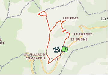
SityTrail - Col Ratti depuis Encrenaz

olivieraron
User

Length
8.6 km

Max alt
1913 m

Uphill gradient
533 m
Km-Effort
15.7 km

Min alt
1430 m

Downhill gradient
537 m
Boucle
Yes
Creation date :
2021-08-02 16:08:17.36
Updated on :
2021-08-02 16:08:45.441

FREE GPS app for hiking
 SityTrail
IGN / Geographical institutes
SityTrail Plus
The world is yours!
About
Trail of 8.6 km to be discovered at Auvergne-Rhône-Alpes, Upper Savoy, La Côte-d'Arbroz. This trail is proposed by olivieraron.
Description
Départ du Col de l'Encrenaz, marcher jusqu'au hameau "Les Paquis", puis col de la Basse, puis col Ratti, retour au col de la Basse, puis col de l'Encrenaz. Comptez 3h30 hors pause pique nuque.
Positioning
Country:
France
Region :
Auvergne-Rhône-Alpes
Department/Province :
Upper Savoy
Municipality :
La Côte-d'Arbroz
Location:
Unknown
Start:(Dec)
Start:(UTM)
317336 ; 5115959 (32T) N.
Comments